Descent Through Heaven – Urcos to Mazuco, Peru
TRIP INFO BOX |
|
| Route | Urcos, Peru – Mazuco, Peru (26/30C “Interoceania”) |
| Distance | 282Km |
| Travel Time | 10.5 hours |
| Road Conditions | Excellent asphalt, 5star descent after Saqsaywoman to Mazuco |
| Weather | Rain/hail on altiplano, overcast on descent |
| Terrain | Ascent after cuzco, 5000m descent from glaciers to tropical jungle |
| Food and Petrol | Frequent |
| Accommodation | Hospedaje in Mazuco |

Our delayed departure from Urcos (see reason below) starts at near midday. Doesn’t look like we’ll make it to Puerto Maldonado as planned.

The delay? During an oil top-up in the Urcos hostel courtyard, the fully loaded bike takes a drop on its side and the open oil sump spills out most of its contents. (Thankfully the hosts are really cool about it though). Being Sunday – conveniently – it takes me a good deal of time and energy to find a suitable replacement oil, a baking hot walk to the edge of the town. We finally hit the road near midday!

Soon after we leave it starts to rain. The serpentines out of the valley are wet and we hit a number of muddy road works, where water has washed away the road surface. Not good riding conditions. The road improves much after about an hour but it’s still wet and we’re pretty high up, riding through the historical area of Saqsayhuaman. We drive on several kilometres through barren alpine landscape and the rain turns to hail. Fortunately we’re just near a small town and we pull into a petrol station, under which we take shelter. We’re freezing.

The attendant comes out and chats to us. The building next door is a motel under construction. He offers us a place to stay there but it’s under construction and there is no one else there so we’re not sure it’s secure. We look into the little town but the places there are pretty dire as well so we decide to move on.

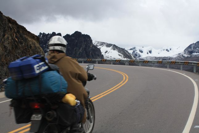
After some time we reach the highest part of the terrain, on the Abra Pirhuayani pass, and it is unbelievably beautiful! On the horizon there are steep, dark monoliths, surely around 6000m in altitude, with magnificent glaciers sitting in-between them. At their base a plateau of soft-looking yellow-green grass or moss, little streams of heavenly-clear water trickling through it in narrow channels, dividing up the plateau into little islands. There there are a multitude of short animals with thick fur grazing, and in the distance some small farm houses.
[UPDATE:] I’ve subsequently found this could-must-may have been the Ausangate mountain range.

We park on a mound there and stop for a while, taking in the scene. It’s high and cold but the tranquility of the place flows through our bodies like an electricity and we feel only exaltation and love for this beautiful planet.

We are at about 5000m altitude. The road takes us closer and closer to the rocky peaks until they’re seemingly just out of reach to the right of us. Then we begin the descent into the valley on the other side, a scene we couldn’t have dreamed to witness!

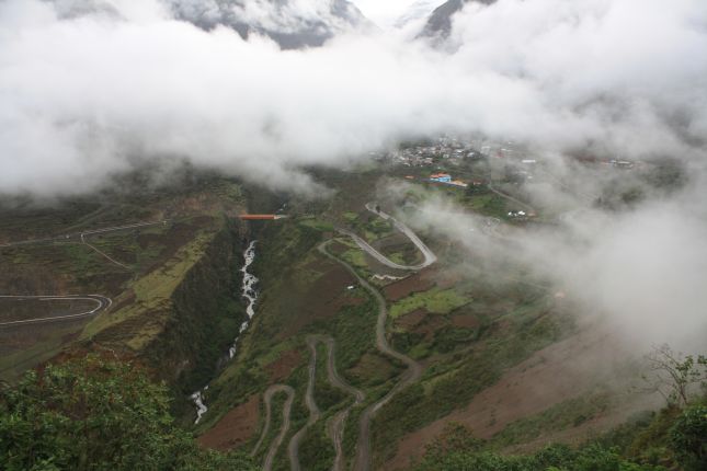
The pristine black asphalt road winds steeply down beside the rock face towering above us until it reaches a plateau. You think you must have hit the bottom, but then you turn a corner and another plunge down the mountain side beings, taking you over large bridges, through villages and farms. Below you you can often see a sea of clouds awaiting. And after you’re through it, yet another.

In a number of hours we descend from alpine desert, above 5000 metres, through various stages of brush and tree forest, into lush tropical jungle landscape with numerous large rivers to cross. This route is definitely the most spectacular one we have ever rode. In fact, we decide, it is so beautiful that the next day we have to take another ride up and back down just to take additional photographs. It’s heavenly!

We’re in jungle territory when it gets dark. It’s not a desirable situation but this is where we are and we have to get onwards to shelter. We ride very carefully and the road surface is very good but there are a number of rock falls along the way which need to be navigated cautiously.

It takes us about three hours of night driving to reach the small town of Mazuco. (An hour before that we pass through Quincemil but that looks so dodgy that we decide to move on.) It looks dodgy too but it’s not as bad as Quincemil, and Ebru discovers quite a nice little accommodation at a newly built hotel. I don’t recall the name of it. It’s not the big flashy one on the main street on the right when you enter, but a bit further down on the right and it has a sign outside advertising “Hospedaje” and a gold exchange next door. The Hospedaje costs us 45PEN/dbl, it’s clean and has a courtyard to park the bike in. (There is only one ATM in Mazuco, near the entry of the town.)


One Comment
Pingback: